
Son Tra is the green headland you see across the water from My Khe beach, crowned by a giant white statue that watches over the bay. Locals call it Monkey Mountain. It holds Da Nang's most photographed sight, some of the city's best viewpoints, and one of the rarest primates in the world. It is also the one place near Da Nang where getting around has real rules, so this guide covers both what to see and how to reach it safely.
The short answer
Lady Buddha height
67 m
Pagoda entry
Free
Pagoda hours
~6am - 9pm
From city center
~10 km, 20-25 min
Doucs on Son Tra
1,300+
Auto scooters
Barred on mountain routes
What and where is Son Tra Peninsula?
Son Tra is a forested headland and nature reserve about 10 km northeast of central Da Nang. The name likely comes from the wild son tra trees that grow here, while the nickname Monkey Mountain came from American forces during the Vietnam War, for the many monkeys on the slopes. Because of its position over the harbor, the US military built a radar facility and a helicopter pad on top.
Today it is a rare thing: a large protected wilderness right on the edge of a growing city. The reserve holds more than 1,000 plant species and around 360 animal species, and its ridges give some of the widest views in central Vietnam. Most visitors come for the Lady Buddha, but the peninsula rewards a slower look.
The Lady Buddha and Linh Ung Pagoda
The Lady Buddha is the headline. At about 67 meters, it is Vietnam's tallest statue of its kind, roughly a 30-storey building, standing on a lotus pedestal about 35 meters wide. It depicts the Bodhisattva of Compassion, known here as Quan Am, with one hand raised in teaching and the other holding a jar of holy water, facing out to sea. It was unveiled in 2010, and inside it is hollow, with 17 interior levels.
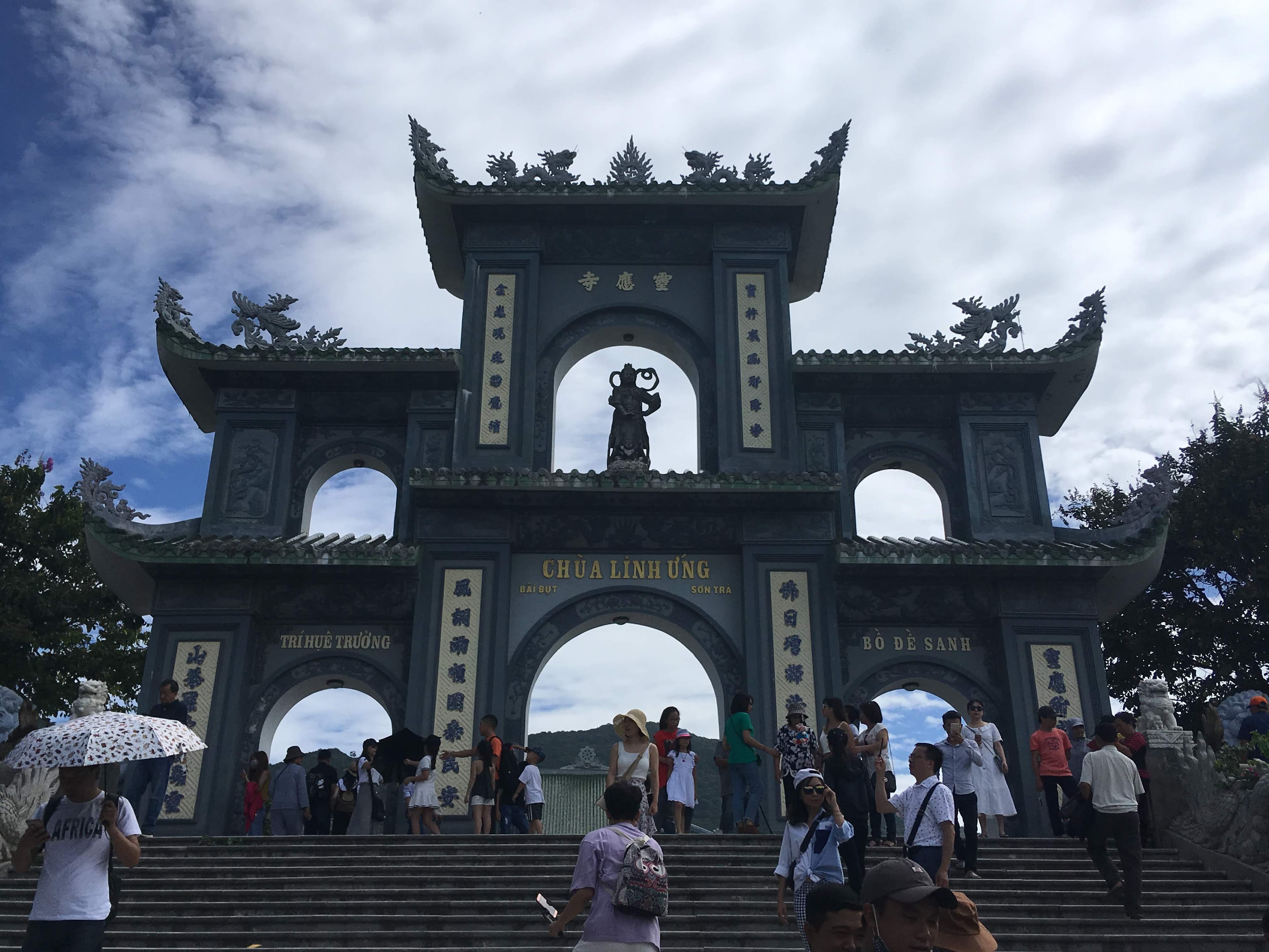
It stands at Linh Ung Pagoda, a working temple with wide views over the bay. Entry is free, with donations welcome, and the pagoda is typically open from about 6am to 9pm. Coastal fishing communities pray to Quan Am for protection from storms, and a local legend tells of fishermen who found a Lady Buddha statue washed ashore and built a shrine on the spot.
Dress for a temple
This is an active place of worship, so cover your shoulders and knees. Skip tank tops and short shorts. If you are coming straight from the beach, carry a light scarf or sarong to cover up before you go in.
Is this the same Lady Buddha as the Marble Mountains?
This trips up a lot of visitors. No, they are different. The famous 67 m Lady Buddha that fills the photos is the one on Son Tra. Confusingly, Da Nang has three separate Linh Ung Pagodas: the one on Son Tra, an older one at the Marble Mountains, and a third at Ba Na Hills. The Marble Mountains have their own, separate Quan Am veneration.
If you want the full story of the Marble Mountains site and its caves, our Marble Mountains guide covers it, and the Ba Na Hills pagoda features in our Ba Na Hills day trip guide. Between them, that clears up which Lady Buddha is which.
The best viewpoints and photo spots
Beyond the pagoda, Son Tra is about the views. Here are the spots worth the drive, and roughly how long each takes.
| What it is | Time needed | Note | |
|---|---|---|---|
| Linh Ung Pagoda + Lady Buddha | Free temple, 67 m statue, sea views | 45 - 75 min | The easiest sight, low on the peninsula. |
| Ban Co Peak (chess statue) | ~700 m viewpoint, full city panorama | 45 - 90 min with drive | Reached by a steep route; best at sunrise. |
| Thousand-Year Banyan Tree | An 800-plus-year-old heritage banyan | 30 - 45 min | Access road is rough; can close after landslides. |
| Bai Bac / north coast | Scenic coast and a landmark resort | Drive-by / photo stop | A waypoint on the coastal loop, not a public site. |
| Tien Sa area / lighthouse | Beach and an early-1900s lighthouse | Optional 30 min | Some nearby routes close for repairs. |
Ban Co Peak is the standout, an immortal-sage statue seated at a giant stone chessboard, about 700 meters up, with the whole of Da Nang spread below. The full hiking trail is hard, roughly 15 km round trip with about 780 meters of climbing over 5 to 6 hours, so most casual visitors drive up rather than walk.
The red-shanked douc: the queen of primates
Son Tra shelters one of the world's most striking monkeys, the red-shanked douc langur, nicknamed the queen of primates for its colorful coat. Recent surveys count more than 1,300 here, the largest and most stable population of the species, which the IUCN lists as endangered. Numbers have fallen sharply across their wider range, so this urban-edge refuge matters.
To see them, come early. They are most active and easiest to spot in the cool of the morning, roughly 6 to 9am, high in the tall trees along the quieter roads. Move slowly, keep your distance, and never feed them. Feeding wild langurs harms their health and changes their behavior, and it is exactly what conservationists here are trying to stop.
How to get there and get around
The peninsula is about 10 km northeast of the center, roughly 20 to 25 minutes by taxi or Grab, and a taxi from the airport to Linh Ung Pagoda runs around 200,000 VND. There is no public bus or train, so your options are a car, a taxi or Grab, a motorbike, or a bicycle.
- Car, taxi, or Grab: the easiest choice, and the only sensible one if you are flying out the same day. Drivers handle the steep roads for you.
- Private car with driver or a half-day tour: best if you want the pagoda plus a viewpoint without navigating the restricted routes yourself.
- Manual or semi-automatic motorbike: needed for the steep controlled routes; confident riders only.
- Automatic scooter: fine for the lower and coastal areas and the pagoda, but barred from the steep mountain routes (see below).
- Bicycle: possible on the lower sections, but the full climb is very demanding.
For the wider picture on Grab, bikes, and fares across the city, see our getting around Da Nang guide.
Can you ride a scooter up Son Tra? The ban explained
This is the single most important safety fact on the peninsula. The reserve management bars automatic scooters, and buses over 24 seats, from the steep controlled routes such as those toward Ban Co Peak and the Banyan Tree. The reason is mechanical, not bureaucratic: automatic scooters have no engine braking, so on a long, steep descent the brakes overheat until they fail. People have crashed doing exactly this.
Checkpoints enforce the rule, so do not plan to ride a rented Vision, PCX, or Vespa up the mountain. The mountain routes also have their own access hours, separate from the pagoda: roughly 7:30am to 6:30pm from March to September, and 7:30am to 5:30pm from October to February. Roads can close after storms or landslides, and the access rules change by season and management notice.
Check before you climb
Access rules, open routes, and hours shift often, and the Banyan Tree road in particular can be closed by landslides. Confirm the current situation with your rental shop or the on-site staff before you head up, and follow the signs and checkpoint instructions when you get there.
Best time of day and season to visit
For the day, early morning is best: cool light, low cloud over the peaks, and the most active langurs, from about 5 to 7am. Late afternoon, after 4pm, is the pick for sunset over the city. Midday is hot and hazy, and the open plaza at the Lady Buddha gives little shade.
For the season, the dry months from about March to September give the safest roads and the clearest photos. January and February can bring a dramatic sea of clouds at the peaks, but also wetter, greyer conditions. Bring a light jacket for an early ride, since it is cooler and breezier up top. If you are timing a whole trip, our best time to visit guide has the month-by-month detail.
A suggested half-day route
A focused Son Tra visit fits neatly into half a day, about 3 to 4 hours including transport. Start early, beat the heat, and you can still be back for lunch or a beach afternoon.
- Leave the city around 6 to 6:30am by car or a manual bike, watching for langurs in the trees on the quieter roads.
- Drive up to Ban Co Peak for the sunrise panorama, then come back down while the light is still soft.
- Stop at Linh Ung Pagoda and the Lady Buddha, allowing 45 to 75 minutes, and dress to cover shoulders and knees.
- Add the coastal loop past Bai Bac and the lighthouse if roads are open, then head back to the city.
Because the peninsula, the beach coast, and the airport all sit on the same side of the city, Son Tra also makes a natural last stop on a departure day. To slot it into a wider trip, see our Da Nang itinerary.
On your departure day
Do the Son Tra loop bag-free, then head straight to the airport.
Near the airport
~10 min
By the day
60,000 VND (up to 24h)
Open
7am - 10pm daily
New to Stow? See how luggage storage in Da Nang works.
Questions people ask
How tall is the Lady Buddha in Da Nang?
About 67 meters, which makes it Vietnam's tallest statue of its kind, roughly the height of a 30-storey building. It stands on a lotus pedestal about 35 meters wide at Linh Ung Pagoda on the Son Tra peninsula, and it faces out to sea.
Is the Son Tra Lady Buddha the same as the one at the Marble Mountains?
No. The famous 67 m Lady Buddha that most tourists photograph is on the Son Tra peninsula. Da Nang has three separate Linh Ung Pagodas, at Son Tra, the Marble Mountains, and Ba Na Hills, and the Marble Mountains have their own, older Quan Am site.
Is Linh Ung Pagoda free, and what are the opening hours?
Entry is free, with donations welcome. The pagoda is typically open from about 6am to 9pm daily. Note these are the pagoda's hours; the steep mountain routes to the viewpoints have separate, shorter access hours set by the reserve management.
What is the dress code at the Lady Buddha and Linh Ung Pagoda?
Cover your shoulders and knees. Avoid tank tops, short shorts, and short skirts, since it is a working temple. Lightweight long clothing is fine in the heat, and a scarf or sarong is an easy cover-up to carry if you are coming from the beach.
Can you ride a scooter up Son Tra?
Not an automatic one on the steep mountain routes. The reserve management bans automatic scooters from routes like Ban Co Peak and the Banyan Tree, because automatics have no engine braking and the brakes can overheat and fail on long descents. Use a manual or semi-automatic bike, a car, or a tour.
Why is Son Tra called Monkey Mountain?
American forces nicknamed it Monkey Mountain during the Vietnam War for its many monkeys, including the red-shanked douc langur, and the US also ran a radar facility on top. The name Son Tra itself likely comes from the wild son tra trees that grow on the headland.
Will I see monkeys or langurs on Son Tra?
Often, yes, especially in the cool early morning between about 6 and 9am, high in the trees along the quieter roads. More than 1,300 endangered red-shanked doucs live here, the largest population of the species. Watch them quietly from a distance and never feed them.
How far is Son Tra from Da Nang, and how do I get there?
The peninsula sits about 10 km northeast of the city center, roughly 20 to 25 minutes by taxi or Grab. There is no bus or train, so you reach it by car, taxi, motorbike, or bicycle only. A taxi from the airport to Linh Ung Pagoda costs around 200,000 VND.
What is the best time of day to visit Son Tra?
Early morning, from about 5 to 7am, gives cool light, low cloud, and the most active langurs. Late afternoon, after 4pm, is best for sunset over the city from the peaks. Midday is hot and hazy, and the open plaza at the pagoda offers little shade.
How long do I need for Son Tra?
A focused visit to Linh Ung Pagoda plus one viewpoint is a comfortable half day, about 3 to 4 hours including transport. If you want to hike, spot langurs, and reach the Banyan Tree, budget most of a day and check road access before you go.
Sources
- 1.Vinpearl: Linh Ung Pagoda and Son Tra Mountain · the statue height, location, name origin, and the reserve's radar history
- 2.DanangBike: Monkey Mountain scooter ban · the automatic-scooter ban, route-by-route status, and the mountain access hours
- 3.Vietnam Coracle: Son Tra motorbike guide · the riding routes, road hazards, landslide risk, and coastal landmarks
- 4.Nhan Dan: 1,300+ red-shanked doucs in Son Tra · the current douc langur population figure
- 5.GreenViet: red-shanked douc langurs · the conservation status and the local surveys of the species
- 6.Hoi An Day Trip: Ban Co Peak · the Ban Co Peak viewpoint, the chess statue, and the panorama
- 7.Your Vietnam Travel: the three Linh Ung Pagodas · the disambiguation between Da Nang's three Linh Ung Pagodas
- 8.AllTrails: Ban Co Peak Son Tra trail · the full hike distance, elevation gain, and time
Access rules, route closures, and opening hours on Son Tra change with the season, the weather, and management notices. This guide reflects the situation at the time of writing; check current signs, staff instructions, and your rental shop before you head up the mountain.